Streamline your field operations with AI-powered data collection
The Digital Fieldbook is a purpose-built mobile solution designed specifically for forestry professionals that revolutionizes how data is collected, processed, and utilized in the field. This comprehensive platform replaces traditional paper-based methods with powerful digital capabilities enhanced by artificial intelligence.
Developed by a forester for foresters, the Digital Fieldbook understands the unique challenges of collecting high-quality data in remote locations, difficult terrain, and variable weather conditions. The result is a seamless system that improves data quality while reducing collection time by up to 60%.

AI-Powered Species Identification

Precision GPS Mapping

Customizable Data Collection
Works seamlessly without cellular coverage. Collect data anywhere in the field with automatic synchronization when connectivity is restored.
Captures precise locations with support for external GPS receivers. Records position accuracy with each data point and automatically tags all collected information.
Collect photos, audio notes, measurements, and observations in a single integrated system. All media is automatically geotagged and linked to relevant data entries.
Identify tree species, pests, diseases, and plant communities using advanced machine learning algorithms that work even without internet connectivity.
Synchronize with secure cloud storage for team collaboration, data backup, and integration with existing forestry management systems and GIS platforms.
Create tailored data collection protocols for any forestry application including inventory, wildlife surveys, stream assessments, and compliance monitoring.
The Digital Fieldbook goes beyond generic data collection with AI-powered apps specifically tailored to different forestry contexts, regulatory environments, geographic regions, and client requirements. Our customization approach ensures you get exactly what you need without the complexity of features you don't.
Our AI models are fine-tuned for the specific tree, plant, and fungi species in your geographic region, whether you're working in coastal British Columbia, the boreal forests of northern Canada, or the mixed hardwood regions of eastern North America. The system provides:
Our regulatory compliance modules ensure your data collection meets all requirements for your specific jurisdiction and certification standards:
Field conditions vary dramatically across different terrains, and our app adjusts automatically to optimize for your working environment:
Different clients require different reporting formats, data structures, and deliverables. Our system automatically adapts to these requirements:
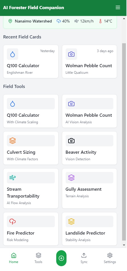
The Digital Fieldbook platform includes specialized AI assistants that actively support your field operations, making complex tasks simpler and more efficient:
The AI analyzes terrain, access points, and sampling requirements to generate optimized survey routes that minimize travel time and maximize data collection efficiency, accounting for:
Using computer vision and machine learning, this assistant helps identify and diagnose forest health issues with remarkable accuracy:
Specialized for water feature identification, classification, and assessment in forested environments:
Transforms your raw field data into polished, professional reports while still in the field:
Reduction in data collection and processing time compared to traditional methods
Decrease in data entry errors through validation rules and automated quality checks
Improvement in data completeness and consistency across field teams
Continuous access to collected data for immediate analysis and decision-making
The Digital Fieldbook comes with pre-configured templates for common forestry applications, saving you setup time and ensuring best practices in data collection:
Comprehensive stand-level data collection including species composition, diameter distributions, height sampling, and timber quality assessments.
Systematic sampling protocols for seedling establishment, growth monitoring, and stocking assessments with spatial distribution mapping.
Early detection protocols with AI-assisted identification, severity rating systems, and outbreak tracking functionality.
Streamside habitat evaluation, water quality parameter collection, and riparian vegetation inventory with regulatory compliance checks.
Fuel loading quantification, hazard rating protocols, and defensible space evaluations with photo documentation.
Habitat feature inventory, sign recording, and wildlife observation protocols with species-specific data fields.
We'll discuss your specific data collection needs, current workflows, and integration requirements to ensure the Digital Fieldbook is properly configured for your operation.
Your Digital Fieldbook will be set up with the forms, reference data, and integration connections required for your specific forestry applications.
Comprehensive training session for your field staff and office team to ensure everyone is comfortable with the new system and understands best practices.
Hands-on assistance with your first data collection projects, ensuring smooth implementation and addressing any questions that arise in real-world conditions.
Continuous technical support, regular updates with new features, and consultation on optimizing your data collection protocols as your needs evolve.
Contact me to schedule a personalized demonstration of the Digital Fieldbook tailored to your specific forestry operations.
Schedule a Demo